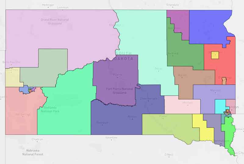
While the Senate members were sending out and publicizing the background information for their map, the House Redistricting Committee had it a bit more hidden, and attached to a .pdf document deep in the LRC website.
I’ve dug it out for your review, since nobody else seems to be doing it, and you have your own chance to read what the House is relying on as the logic behind their “Grouse 2.0” Legislative Redistricting map:

Grouse Support by Pat Powers on Scribd
Could we say that the document is in support of more grousing?

Splitting Aberdeen? Unnecessary.
Clarification: Turner county residents want to stay with clay county. Clay county residents largely have no reason to care what happens to Turner county, who have more in common with district 19 than clay county. Clay county has more in common with EPJ, DD, and NSC for the reasons several senators have repeatedly identified. Rasmussen and that cohort just want a redrawn district to give them more of an edge to off Rusch and the more moderate wing in a primary.
This whole map is pathetically transparent self-serving dog crap, and it’s proponents either know that or are too obtuse to be making any decisions on behalf of the citizenry.
Rusch is a self serving politician who’s only worry is giving judges unlimited power and authority.
That’s an ill-informed statement. I might not agree with him on every issue, but I would not doubt his intelligence or sincerity, and I don’t know that any of his colleagues would say that Art Rusch is anything but a gentleman. He’s a pretty good guy.
I’m not sure why people are all of a sudden taking shots at him, especially since he’s termed out of office.
Rusch is term limited.
This plan would have citizens from three different legislative districts voting in the New Underwood Community Center precinct…27, 29, and 30!
This is better than it was. I don’t mind the District 23 and 24 configuration. D 26 isn’t bad but seems like Gregory should be with Winner. The Aberdeen split I’m not crazy about — no ideal situation here with the city’s population being more than the target amount — but seems that we shouldn’t split Aberdeen equally — gives them a pretty good head start on winning six seats when I’m not sure they should have that many. I think they should have one district of about 26,000 and then carve out a small portion of Aberdeen to be included in a rural district.
Was this to address the whining from district 25? Why not just let Dell Rapids rule the entire state? Create a giant pizza type system to allow about 20 of them into the legislature?
Here’s some observations about both maps. Overall, Blackbird appears to be better, but not without flaws. I give them credit for fixing Watertown.
Aberdeen — the Senate has this split better. We shouldn’t split Aberdeen equally, just as we shouldn’t Watertown. It feels like a power grab — give me 60% of the vote from Aberdeen and they’ll take six seats from two districts. The Senate Blackbird plan does have one flaw in Brown county — Dist 23 wraps around to the East of Aberdeen and District 1 wraps to the West of Aberdeen. This needs to be fixed — Groton should be in 1. Let’s not make this look gerrymandered.
District 17 — much discussion about Vermillion. I don’t know that it’s a huge deal either way. The only thing that struck me as odd is the House version has Vermillion with Freeman. Vermillion seems more tied to Union county than the Freeman area.
District 23 is a little difficult because of it’s sparsity. Seems like we shouldn’t go down and split Beadle. I’d rather see Hyde county in that district — it’s a better fit here. And if we stick with the Senate version, it ought not go to Groton — straighten the lines a little bit.
District 24 — I tend to like Pierre and Fort Pierre with Sully, Lyman, and Jones like the grouse map has set up, rather than with Haakon. Midland trade market is Pierre, but Phillip is closer to Kadoka, Wall, etc.
re: Tripp and Gregory county — they should be together. On the Grouse map, District 26 should include Gregory and then move Brule to district 19. Again, both of these maps look to be creatively drawn in these counties, partly because of the split district I suspect. But do we have some politics involved as well?
Sioux Falls – the Blackbird map is clearly better.
Rapid City looks a bit odd on both maps. Grouse looks better in terms of lines, but it’s odd to have North Rapid with West Rapid. We can do better on these RC maps without having North Rapid with West Rapid or with Pactola. Someone who knows RC and without political interest or motives should spend some time on these lines.